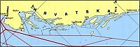
Šibenik area stretches
southeast of the island of Pašman and Kornati archipelago
to the cape of Ploče which is a continuation of sea routes
from the Srednji kanal Strait and the Pašman Strait across
the sea of Murter to the ports of Šibenik area. From
the sea of Murter one sails in southeast direction through
the straits Žirjanski kanal, Kakanski kanal, Kaprijski
kanal, Zmajanski kanal, Zlarinski kanal and Šibenski
kanal and further on from the cape of Ploče towards the
Split area.
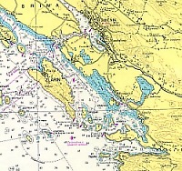
When sailing from open sea, this area can be reached
through the passage Samogradska vrata (situated between
the southern part of Kornati archipelago and the island
of Žirje) and from the southern side, between the island
of Žirje and the land coast.
Weather conditions: a gale force north eastern wind
blows over the entire area causing great waves and
billows with sea dust. A gale force south wind and
SW wind cause great waves at sea, except in the lee.
The NW wind and tramontana can cause great waves along
the coastline between the cove of Grebaštica and the
cape of Ploče . Fog can come down 2-5 days per year.
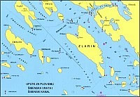
There are three passages to the Šibenik Strait : through
Loguranska vrata towards the southern side of the island
of Prvić ; through Šibenska vrata between the islands
of Prvić and Zlarin and between the islands of Zlarin
and Dvainka. The most frequently used passage is the
one between the islands Prvić and Zlarin. When approaching
the Šibenik Strait from south in the period when south
winds blow, it is recommended that ships enter port
through the passage between the islands of Zlarin and
Dvainka.
The Šibenik harbour outside anchorage is situated
1-2 NM SE from the island of Zlarin and it is used
in extremely bad weather.
The internal anchorage of Šibenik port is situated
west of the island of Krapanj between the island of
Drvenik and the hotel complex, Solaris, which is situated
on land and it is marked by:
|
A
|
width
|
43° |
40’ |
30"
N |
|
length
|
15° |
52’ |
45"
E |
|
|
 |
|
B
|
width
|
43° |
41’ |
25"
N |
|
length
|
15° |
52’
|
45"
E |
|
|
|
|
C
|
width
|
43° |
40’ |
40"
N |
|
length
|
15° |
53’
|
00"
E |
|
|
|
|
D
|
width
|
43° |
40’ |
00"
N |
|
length
|
15° |
53’ |
50"
E |
| |
Sea
depth in the anchorage 24 m |
Harbour pilotage in
the area of Šibenik port, the port where pilotage is
compulsory and where the Harbour Authority of Šibenik
regulates the boundaries of compulsory pilotage and time
and place of embarkation/disembarkation of the pilot.
Pilotage in Šibenik port is done 24 hours a day. The
place of embarkation/disembarkation
of the pilot is the pilot station 0,5 NM N from Drvenik
lighthouse on the island of Drvenik .
The position
of the inside pilot
station
| width |
43° |
41’ |
30"
N |
| length |
15° |
52’ |
18"
E |
Coastal pilotage is done in order to enter Šibenik
port, which is open for international traffic from
the position:
| width |
43° |
38’ |
42"
N |
| length |
15° |
52’ |
18"
E |
to the boundary of harbour pilotage .
|